“Then Joshua spoke to the Lord on the day when the Lord delivered up the Amorites before the children of Israel, and he said in the sight of Israel, “Sun, stand still upon Gibeon, and Moon in the valley of Ajalon. And the sun stood still, and the moon stayed, until the people had avenged themselves upon their enemies (Joshua 10:12-13)”

Photo Credit: Shutterstock
Today, we are visiting the enchanting Ayalon Park Canada. This centrally located park (roughly between Jerusalem and Tel Aviv) has it all: beautiful (family-friendly) trails with lots of greenery and wild flowers, planted forests of fruit trees (when in season, the blooming white flowers of the almond trees are gorgeous), picnic tables, and well preserved, archeological ruins (beautifully integrated into the parks landscape). The park offers stunning views of the Biblical Ayalon valley below, our main focus for today.
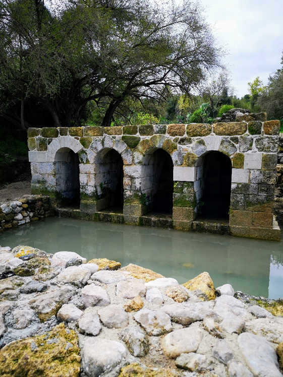
Photo Credit Shutterstock
The Ayalon Valley, given to the tribe of Dan, was (and remains today) one of the most strategic valleys in all of Israel. Today’s two highways (same routes as the ancient highways) connect Jerusalem to Tel Aviv and the rest of the coast (highways 1 and 443) and go through the valley. Due to its central location, many wars were fought here, including arguably the most dramatic event in Biblical history. Joshua and his army defeated the city states of Jericho and Ai. The powerful city of Gibeon made an alliance with the Israelites (see previous article on Hazor where I discuss the structure of Canaanite city states, Tel Hazor). Five Canaanite kings attacked Gibeon (for more on that, click here) sending a message that making peace with the Children of Israel was not in their interest. When they attacked, Joshua felt bound by his oath and came to their rescue. As the armies of the five kings saw him coming, G-d put panic into their hearts and they were smitten, with the survivors fleeing by way of the “Ascent of Beth-horon”. As they started to descend from Beth-Horon, G-d sent a hailstorm that finished off most of the remaining troops (Joshua 10). According to Jewish sources, these actual hailstones were left over from the plague of hail in Egypt. When Moses asked G-d to stop the plague (see Exodus 9:33) the remaining hail was saved. With the death of most of the Canaanite troops, the remainder kept fleeing westward through this valley and the sun was quickly setting (according to Jewish sources, it was Friday evening and therefore almost Shabbat). In order to take care of the job before sundown, Joshua prayed to G-d for the sun to stand still (which it did) and it didn’t set until the enemies had been destroyed and the war was over (see Joshua 10).

Photo Credit: freebibleimages.org
Located on the grounds of the park are the ancient ruins of Emmaus, a major city in ancient times and the location of the Battle of Emmaus in 165 BCE (whose battle strategy is still studied in military academies around the world). During the anti-Torah decrees of the mighty Hellenist rulers (circa 2nd century BCE) a small group of pious Jews led by the Maccabees (5 brothers) rebelled. Against all odds, they defeated the powerful Greek army in the first two battles in military upsets. They also had Jerusalem (controlled by the Greeks) under siege. The Greeks built a heavily fortified town in Emmaus. The leader of the brothers, Judah, gathered his men to Mizpah (for more on that site, click here) and intentionally “leaked” the information to the Greeks in order to lure them into a trap. The Greeks, led by General Gorgias, took the bait and sent thousands of their best soldiers to attack them in a “surprise” night time raid (leaving some of the men at Emmaus). Judah in turn led his men down to Emmaus by the Ayalon Valley and attacked the remaining sleeping camp from behind, massacring thousands and causing the rest to flee to Gezer (for more on that click here). Subsequently, Judah burned the powerful Greek fortifications and took over their advanced weaponry for future battles. When General Gorgias (whose troops were tired by being all night on a fruitless search) returned and saw the camp on fire, he panicked and fled to the area of Philistines, thus leaving Jerusalem under the siege of Jewish forces (for more on the next two battles, click here).
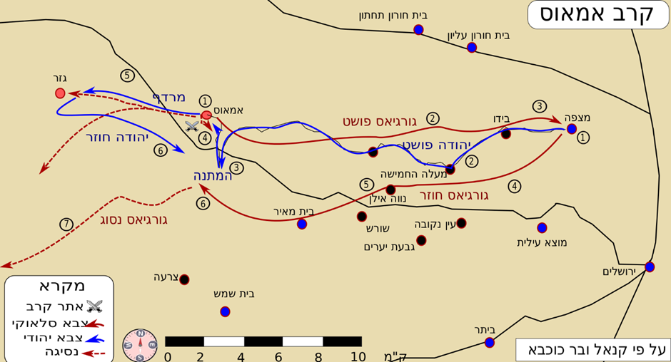
Photo Credit: Effib – CC BY-SA 4.0
Not only was the area important to control for strategic reasons, but also agriculture as the Ayalon Valley, including around Emmaus, had abundant (underground) water springs. For this reason, sophisticated Roman aqueducts have been found in Park Canada which led water from springs above to the fertile fields of the Ayalon valley below. This is why the entire Ayalon Valley (even today) is filled with so many Israeli agricultural towns and Kibbutzim.

Photo Credit: ShutterStock
Even in modern times, the Ayalon Valley has been a strategic priority for the State of Israel and the site of deadly battles where many IDF soldiers lost their lives. Just a few minutes away from Park Canada is the Israeli Tank Museum of Latrun (a worthwhile place to visit when in the Ayalon Valley area). Part of the museum is located in an old, but formidable British fortress built in the 1930s to end the Arab revolt of 1936-39. The fortress was built here because it controlled one of the most important junctions in the country (where Highway 1 meets Highway 3). When the British left in 1948, Jordan quietly took over the fortress which meant that Highway 1 became unusable, and Jerusalem was under siege. Israel fought 5 unsuccessful battles here with extremely high casualty rates to the IDF which included 168 dead, at least 327 injured and 19 captured (tragically, around 50% of soldiers fighting at Latrun were Holocaust survivors fresh off the boat).

Photo Credit: Bukvoed – CC BY 2.5
Failure to capture this fort, meant that a new road was quickly needed to lift the dire siege on Jerusalem. In July, Israel captured Ramle and Lod (two major cities in the Ayalon Valley) and they were able to build today’s Highway 44. However, because Latrun was not conquered, between 1948-67 one couldn’t take Highway one directly from Tel Aviv to Jerusalem but had to take a much longer bypass route. From Highway 1, you would have had to turn south on Highway 3, then west on Highway 44, north on Highway 38 and West on Highway one.

Photo Credit: משתמש:בן-ציוןממ – CC BY-SA 3.0
In 1967, the Latrun Junction was liberated by the IDF and today, highway one is once again the most important artery in the country. On your next trip to Israel, come and explore Park Canada, ancient Emmaus, Latrun, and all the other great sites located in the Biblical Ayalon Valley!
(All photos are either public domain or licensed by the author for commercial use)
Please visit the author’s Israel tour guiding site: https://guidedtoursofisrael.com


