
Gather the sons of Benjamin from the midst of Jerusalem, and in Tekoa sound the shofar, and over
Beth-hakerem raise a standard, for evil is visible from the north and a great calamity (Jeremiah 6:1).”
“Malkijah the son of Rechab, the prince of the district of Beth Hakkerem, repaired the Dung Gate; he
built it and erected its doors, its locks, and its bolts (Nehemiah 3:14)”

Photo credit: Shutterstock
Today we are visiting a wonderful treasure, right in the heart of Jerusalem. Although surrounded by Jerusalem neighborhoods on all sides, it is not officially part of the Holy City’s municipality but rather is its own independent Kibbutz. Now called Ramat Rachel, many archaeologists have concluded that this was the site of Biblical Beth-HaKerem (in Biblical times this site was a major administrative center). In addition to the beautiful archeology, the Kibbutz also has unique outdoor artwork, enchanting olive orchards, and one of the best panoramic views of Jerusalem and Bethlehem.

Photo Credit: DYKT Mohigan – Creative Commons Attribution 2.0 Generic
Archeologists say that the first to build here was the righteous King Hezekiah, who built a small fortress and administrative center (circa 560 BCE) at the summit of this hill for strategic reasons. Why this particular location? Firstly, it was equidistant from both Bethlehem and Jerusalem’s Old City (3-4 km’s from each) overlooking both. It also stood above the main ancient highway (today’s highway 60) which went through Judah and Samaria. During excavations 164 pottery handles were discovered, having impressions stamped with the words “L’Melech (meaning “To the King”). In the days of Hezekiah, taxes were collected in these jars all over Israel in the form of olive oil, grain, produce, and wine.

In the next phase of the hill (Circa 6th-5th century) the palace expanded into what world famous archeologist Gabi Barkai called “The finest structure ever unearthed from the First Temple period.” It was luxurious, its architectural features well ahead of its time. Eleven (11) Proto-Ionic capitals (out of 16 all together in Israel, including the City of David, Hatzor, Megiddo, and Samaria) were found here. Because these Ionic capital designs are reminiscent of the Judean Monarchy, the modern Israeli Government chose it as the design on the 5-shekel coin today.

Photo Credit: deror_avi – Creative Commons Attribution-Share Alike 3.0 Unported

The palace was surrounded by both an outer and inner casement wall (two parallel walls with some space in between them which can be filled with small stones in between to strengthen the wall from battering rams).

Photo Credit: Bukvoed- CC-BY-4.0
Once entering the walls, one entered a large ceremonial courtyard (still well preserved) paved with whitish crushed limestone. The courtyard led to all of the rooms of the palace.

The palace had a luxurious and super advanced garden (some of the trees were imported from as far away as Persia and Lebanon). The elaborate pool and water reservoir system can still be seen today.

Photo Credit: Bukvoed- CC-BY-4.0
The palace rooms were built with high quality masonry. The shaped stones were built with such an exacting cut, that no mortar was needed to bind them together.

Photo Credit: Bukvoed- CC-BY-4.0
Elaborate window balustrades were also found here. Based on these findings and the period when the palace was built, the archeologist who excavated the site (Yohanan Aharoni) posited that it was built by the wicked King Jehoiakim. Jeremiah criticized the wicked King Jehoiakim by saying “Woe to him who builds his house without righteousness and his upper chambers without justice, who makes his fellowman work without wages and his hire he does not give him. Who says, “I will build myself a wide house with spacious upper chambers, and he cuts out windows for himself, and it is ceiled with cedar and painted with vermilion (Jeremiah 22:13-14)”. According to Aharoni, this criticism is referring to this palace.

Photo Credit: MFA of Israel
During the mid to late 5th century, the Babylonians began to take over Israel. As they approached Jerusalem, Jeremiah told the people of Beth-HaKerem (today Ramat Rachel) to raise the standard (either a flag or banner) for “evil (the Babylonians) is visible from the North and a great calamity” (see Jeremiah 6:1). According to Jewish sources, the purpose of this standard was to gather the troops and fight for their lives, and raising the banner of war from a place where it could be seen in all Jerusalem would make sense. Ultimately the Babylonians took over Israel and destroyed Beth-HaKerem and the first Temple of Jerusalem in 422 BCE (some historians say 586 BCE). The Babylonians were only in control for a few decades until the Persians took over and allowed the Jews to return and rebuild Judea and Jerusalem. Archeology shows that the Persians expanded the palace and made Beth-HaKerem an imperial administrative center (see Nehemiah 3:14 which confirms that this city continued to be the seat of an administrative district and that its residents rebuilt the Dung Gate of Jerusalem).

Photo Credit: MFA of Israel
Soon after, Alexander the Great conquered the Persian empire and the Hellenist Greeks continued to use Ramat Rachel as an administrative center. In the middle of the 2nd century BCE, the Jewish Maccabees took over Israel, and at this site built many Mikvaot (ritual baths) for the masses of Jewish pilgrims who were commanded to come three times a year (Passover, Sukkot and Shavout). To ascend to the Temple, a Jew had to be ritually pure. As this was on the main road to Jerusalem from anyone coming from the South, this would be a convienient location to have them (at least 10 have been found here so far, though more likely existed).

DYKT Mohigan- Creative Commons Attribution 2.0 Generic
During the later Second Temple period (when the Romans first took control of the land) this site continued to be a Jewish city. A columbarium (dove cove) was unearthed here. Doves were in high demand at this time for consumption, the excellent fertilizer they produced, and for sacrifices in the Holy Temple in nearby Jerusalem.

Photo Credit: Shutterstock
During the Great Jewish Revolt, Ramat Rachel was destroyed, and the Hill was abandoned until the 3rd Century CE when the Romans built a ritzy town here. The remains of a Roman Villa and a bathhouse with mosaic floors were found here.

Photo Credit: Bukvoed- CC-BY-4.0
In Byzantine times, the city grew to an estimated population of 5000 people and hosted a large monastery.

In the early Islamic period (circa 7th and early 8th century) the city began to dwindle in importance, until was all but abandoned. It would remain so for more than a millennium, until 1926 when a group of Jewish pioneers came to this deserted land and formed a Kibbutz. The next year, Menachem Ussishkin (one of the most prominent early Zionists) visited here and saw the Tomb of Rachel in the distance (for more on that tomb, click here), calling it Ramat Rachel (which literally translated means the Heights of Rachel). In the summer of 1929, the Arabs infamously rioted against the Jewish population nationwide, killing scores of Jews (67 in Hebron alone). All of the Ramat Rachel homes were burned to the ground, and a Jewish resident was killed. They returned the next year and rebuilt their homes.

Kibbutz Ramat Rachel was the scene of some of the fiercest and most important battles in the 1948 War of Independence when the town switched hands 6 times in a 4 day period (May 21-24). Control here was important because this hill was standing in the way between the Egyptians advancing from the South and the Jordanians coming from the East. The Jordanians met with their Egyptian allies at this spot and rather than fighting together as a cohesive unit, they bickered over who would ultimately control this hill. This infighting would cost them dearly in a matter of days. The women and children were evacuated from the Kibbutz and on May 21, this site was poorly defended by the Jews (about 100 lightly armed locals, 40 Irgun fighters and a few Hagana fighters) while the Arabs had the newest and best weapons and advanced artillery. The fighters asked to be evacuated but Prime Minister David Ben Gurion refused, saying that this hill was all that stood in the way of Jerusalem. After heavy fighting, the Egyptians won and raised their flags in victory (this was the furthest north the Egyptians would ever get). The next night, the Jewish fighters returned and after more heavy fighting, they miraculously recaptured the hill. The next morning, the Egyptians returned and re-captured the hill, though in battles that night, the Jews recaptured the hill. The next morning, Egypt captured the hill for the last time. That night, the Palmach (the elite Hagana strike force unit) entered and recaptured the town, although by now, most of the kibbutz had been destroyed. As a result, the Egyptians gave up on Jerusalem and the Kibbutz members rebuilt their homes. All together, 20 Jews died defending this strategic location while the Arabs are believed to have lost more than 100 fighters. Although the Kibbutz was now firmly in Israel’s hands, the next hill over was taken over by Jordan who built a massive base on this hill called Mar Elias and would often shoot at civilians at Ramat Rachel. In 1956, a major archeological conference was held here and (prior to the many trees here that now exist) the Jordanians had a clear view of the gathering and opened fire, killing 4 civillians and injuring 16 more.

Photo Credit: Bukvoed- CC-BY-4.0
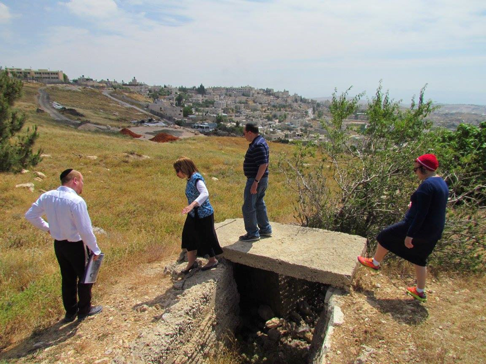
Since this was the border, Israel heavily fortified the hill overlooking Mar Elias. The bunkers and trenches can still be seen by tourists.
The Kibbutz grew produce and fruit here but by the 1980s, like many kibbutzim around the country at this time, they struggled financially and were one of the poorest in the country. In the 1990s they sold 20 percent of their land to developers, allowing new Jewish neighborhoods to be built (which today are very expensive). This turned the Kibbutz into perhaps the richest in the country. The Kibbutz now operates a widely successful hotel (where I have personally stayed) a convention hall and is also a popular wedding venue. They also own a sports center and large pool, and can be rented out for events. Organic crops are now grown (many of which are used to make liqueurs) and they even produce high-tech agricultural products, widely used around the world.

Photo Credit: Shutterstock
As the Kibbutz is now so affluent, in 2002 they developed the beautiful archeological park with their own funds (they were one of the country’s first private institutions to do so without subsequently charging an entry fee). The Kibbutz (still collectively owned) is centrally located, waiting for you to visit on your next trip to Israel!
Please visit the author’s site: https://guidedtoursofisrael.com


